
グリーンランドが大きく見える理由
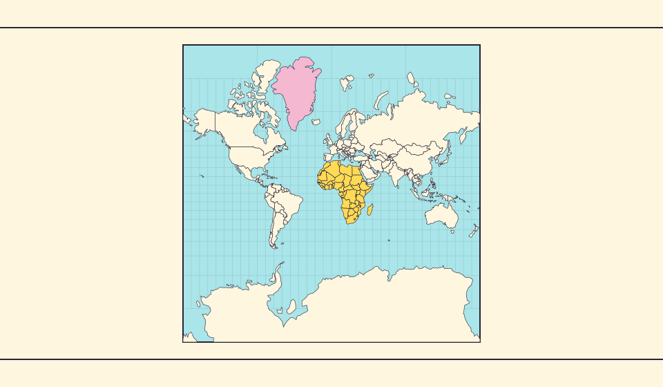
メルカトル図法は極に近い地域を引き伸ばします。そのためグリーンランドは赤道付近の国に比べ、面積以上に大きく見えます。Equal Earth でグリーンランドとオーストラリアを探し、輪郭を比べてみましょう。航海に便利な地図が、面積比較にも適しているとは限りません。
地図が変えるもの
球面メルカトル図法では、局所的な面積倍率は 1 / cos²(緯度) です。緯度60°の小さな土地は、赤道上の同面積の土地の4倍に見えます。国全体の倍率ではありません。局所的な角度を保ちますが、極に近づくほど面積は膨らみます。
出典: Statistics Greenland · Greenland in Figures 2025, p. 34 · USGS · Map Projections: A Working Manual (Snyder, 1987) · USGS · How are different map projections used?
Sources and further reading
Sources checked:
Related stories
Africa is bigger than the map in your memory
The equator crosses Africa, but familiar rectangular maps give northern regions extra space. Compare Africa with countries you know to get a sense of its size.
Equal Earth が保つもの
球面を平面にすると何かが変わります。Equal Earth は相対的な面積を保ち、国の大きさ比較に役立ちますが、形・距離・方向をすべて保つことはできません。地球儀の端では形が圧縮されます。知りたいことに合った地図を選びましょう。
Why online maps stop before the poles
Square tiles make a world map easy to zoom, but Mercator cannot place the poles at a finite height. Learn what the missing polar strip means.