
Why does Greenland look so large?
Try guessing the size of Greenland before reading a number. If your mental picture comes from a rectangular world map, that guess may be doing more than measuring land: it may be measuring the projection. A simple drag experiment helps separate the two.
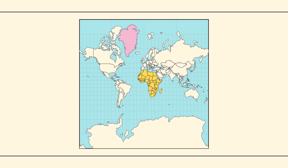
A large island, enlarged again by the map
Statistics Greenland lists a total area of about 2.17 million square kilometres in Greenland in Figures 2025. Greenland is already large. Mercator enlarges its outline further: high-latitude regions receive much more screen space per square kilometre than regions near the equator.
Looking at the outline alone mixes Greenland’s area with the map’s scale. Before ranking it against another place, check whether the two are drawn at comparable local scales and where each sits relative to the equator.
Sources: Statistics Greenland · Greenland in Figures 2025, p. 34 · USGS · Map Projections: A Working Manual (Snyder, 1987)
The four-times example has a limit
For spherical Mercator, the local length scale is 1 / cos(latitude); the local area scale is its square. A very small patch at 60° north or south therefore occupies four times the map area of an equal patch at the equator, at the same map zoom. This follows from the projection equations, rather than a measurement of one country.
It does not mean every northern country is four times too large. A country covers many latitudes, and each part has its own scale factor. Applying one multiplier to the whole of Greenland would hide exactly the variation that makes the map misleading.
Sources: USGS · Map Projections: A Working Manual (Snyder, 1987)
Why keep a map with this distortion?
Mercator preserves local angles, and a route with a constant compass bearing appears as a straight line. Those properties explain its historical value for navigation. Preserving an angle is a different job from preserving the amount of land inside a border.
For a world-area question, switch to Equal Earth. To examine the relationship between a flat map and a curved surface, use the globe. Choose the view according to what you want to compare.
What changes when you drag a country?
In RealWorldMap comparison mode, a selected country can be moved to another part of the map to compare its size. This does not propose a border change. On the flat view, a move toward the equator changes how the spherical outline projects onto the screen.
Keep the map zoom fixed while testing this. Zooming the whole scene between observations adds another change of scale. For a useful comparison, put the countries close together, then inspect their outlines and area figures separately.
Try a fixed-zoom Greenland experiment
- Open comparison mode and search for Greenland and Australia.
- Keep the zoom fixed and move Greenland toward the equator.
- Bring the two outlines near one another, then inspect them on the globe as well.
A changing screen footprint is evidence of projection scale, not of changing territory.
Open the map →
Common questions
Does moving a country provide an official area measurement?
No. It is a visual comparison using boundary geometry. For an official figure, consult a statistical source and its definition of area.
Is Mercator simply wrong?
It has useful angle and navigation properties. Its area distortion makes it unsuitable for judging global relative size from outlines alone.
Sources and further reading
Sources checked:
Related stories
Africa is bigger than the map in your memory
The equator crosses Africa, but familiar rectangular maps give northern regions extra space. Compare Africa with countries you know to get a sense of its size.
Equal Earth: equal areas, different shapes
Equal Earth preserves relative area, but shapes still change. See what it preserves and when a globe helps.
Why online maps stop before the poles
Square tiles make a world map easy to zoom, but Mercator cannot place the poles at a finite height. Learn what the missing polar strip means.