
This story is currently available in English and Korean. You are reading the English edition. 한국어 · English
Why online maps stop before the poles
Zoom out of a familiar online map and the world becomes a rectangle. You may see northern land stretching out, while the actual pole never appears. That boundary is not the edge of Earth. It is a consequence of the projection and the tiled display.
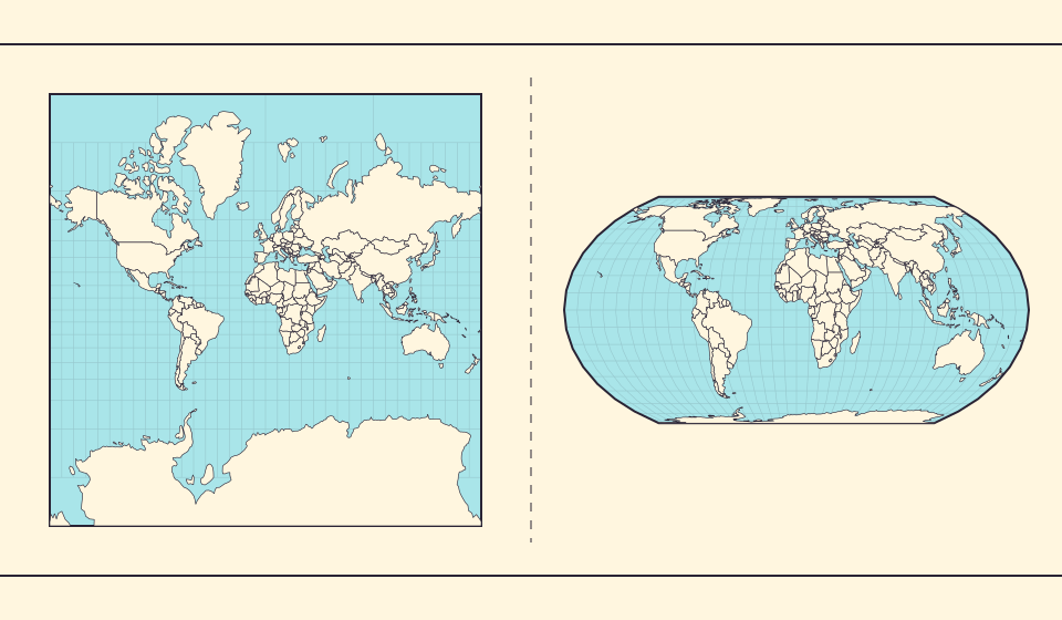
A map made from reusable squares
Google’s Maps JavaScript API documentation describes world, pixel and tile coordinates derived from latitude and longitude through Mercator. At each zoom level the map is divided into tiles. The browser can request the pieces needed for the current view instead of receiving a new image of the entire planet.
The tiles make panning and zooming feel like moving over one continuous canvas. This is convenient for interactive maps, but it does not make the projection equal-area. You still need to account for its scale when comparing country polygons.
The pole would be infinitely far away on the page
In spherical Mercator, the projected vertical coordinate grows without a finite bound as latitude approaches 90°. A usable square world therefore needs a cutoff before the poles. The familiar square tile scheme reaches approximately 85.05° north and south rather than ±90°.
The projection forces the display to omit a polar strip even though land can extend beyond that cutoff. To see the pole in a finite image, use another projection or a globe. A larger browser window cannot solve an infinite-coordinate problem.
Källor: PROJ · Mercator equations · Google Maps · Map and tile coordinates
Zoom fixes readability, not global area distortion
Zooming in gives roads, labels and small shapes more screen space. It does not change Mercator into an equal-area projection. At a fixed location the local scale changes with zoom; the latitude-dependent differences across a large world view remain part of the projection.
A close-up street map can still be useful. To compare areas across the world, though, you need to check how the display scales places at different latitudes. A readable map may still be unsuitable for that comparison.
Why does the world repeat when you pan sideways?
The left and right edges of the square world tiles meet at the same longitude. When the world repeats during sideways panning, the map is displaying another copy of the connected tile grid. It is the same land drawn again to continue a curved world across a rectangular screen.
The map cannot continue toward the poles in the same way. Longitude wraps around the globe, while Mercator’s vertical coordinate grows without limit at a pole. That is why the left and right edges can join, but the top and bottom edges stop before reaching 90 degrees.
Källor: Google Maps · Map and tile coordinates · PROJ · Mercator equations
Find the map’s display boundary
- Zoom out in flat comparison and inspect the northern edge.
- Switch to the globe and rotate toward the pole.
- Compare Antarctica in Equal Earth with its appearance in the rectangular view.
A missing pole describes the map’s limits, not the planet’s limits.
Öppna kartan →Common questions
Can a higher zoom level restore the poles?
No. The Mercator tile extent excludes them. Use another projection or a globe.
Does every online map use this projection?
No. Check the particular map’s documentation and selected view. The explanation here concerns the Mercator tile scheme used by the flat base map.
Sources and further reading
Sources checked:
Related stories
Antarctica is a continent, not the bottom border
A stretched southern strip can hide the shape of a whole continent. Compare Antarctica on Mercator, Equal Earth and a polar globe view.
Varför ser Grönland så stort ut?
Mercatorkartor sträcker områden nära polerna. Grönland ser därför för stort ut jämfört med länder vid ekvatorn. Jämför Grönland och Australien på Equal Earth. En karta för navigering är inte nödvändigtvis bra för att jämföra ytor.
Vad bevarar Equal Earth?
Att platta ut ett klot förändrar dess egenskaper. Equal Earth bevarar relativa ytor, men inte alla former, avstånd och riktningar. Vid globens kant pressas former ihop. Välj vy utifrån din fråga.