
This story is currently available in English and Korean. You are reading the English edition. 한국어 · English
Pangaea was not there at the start of every timeline
Move the time slider to its oldest end and several landmasses appear apart. That may look like a broken Pangaea animation, but the oldest view is six hundred million years ago, well before the Pangaea stage. The timeline covers more than the assembly of one supercontinent.
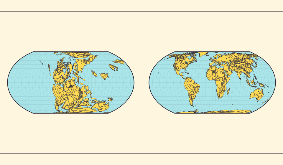
Six hundred million years ago is before Pangaea
The RealWorldMap timeline spans 600 Ma to the present. Ma means million years ago: 300 Ma is three hundred million years ago, not a calendar year. Starting at 600 Ma means starting before the assembly of Pangaea, so separated continental pieces are expected.
The Müller et al. model places Pangaea’s assembly around 320 Ma. A completed Pangaea had not yet formed at the oldest slider position, regardless of the introductory stage labels. Read the selected age before interpreting the arrangement.
Bronnen: Müller et al. (2022) · Plate motion and supercontinent cycles
Continents gather, then separate
Pangaea formed as several continents came together. The Müller et al. model describes its assembly around 320 million years ago and a later interval of stability. At 300 million years ago, the clustered land presents an arrangement very different from today’s separated continents.
Dispersal from around 200 million years ago opens ocean space between landmasses. The interface’s assembly, stability and breakup labels help you follow this long process. Compare the gaps at several ages to see changes that a single picture of Pangaea cannot show.
Bronnen: Müller et al. (2022) · Plate motion and supercontinent cycles
What connects continents now separated by ocean?
South America and Africa have coastlines that suggest a fit. Their shapes are only one part of the evidence. USGS teaching materials also trace related fossils and geological patterns across continents now separated by ocean.
Coastline fits, fossils and rocks together help explain why distant landmasses can belong close together in a reconstruction. Read the ancient map by following those large landmasses and their relationships, rather than looking for today’s country borders.
Follow the opening spaces from Pangaea to today
Move from roughly 300 million years ago toward the present. Landmasses once close together separate as ocean space opens between them, approaching today’s familiar arrangement. Assembly and breakup become easier to follow when you observe the same pieces through time.
Pause around 300 million years ago, 200 million years ago and the present. Compare the changing gaps instead of watching every outline at once. The display follows the MULLER2022 reconstruction; its ancient coastlines are model geometry, not photographs.
Bronnen: Müller et al. (2022) · Plate motion and supercontinent cycles · EarthByte · MULLER2022 dataset v1.2.4 · CC BY 4.0
Geological periods and stages name different things
Turn on the geological-age display to see formal time names alongside the chosen age. Those names describe the geological time scale, while “assembly” and “breakup” describe the supercontinent story. One selected age can have both kinds of labels without the labels meaning the same thing.
For example, 300 million years ago falls late in the Carboniferous, within the Paleozoic Era; 200 million years ago falls early in the Jurassic, within the Mesozoic. Pairing the numerical age with its period name places the changing continents within Earth’s history.
Bronnen: International Commission on Stratigraphy · Geological time scale
Read three ages before drawing a conclusion
- Open continental drift at 600 Ma and note that this is before Pangaea.
- Move to 300 Ma, then to 200 Ma, comparing broad landmass relationships.
- Toggle geological-age labels and compare the time names with the introductory stages.
Distinguish the separated land before Pangaea, the assembled supercontinent and the later dispersal by their ages.
Open kaart →Common questions
Should every land fragment join into one outline?
No. Peripheral blocks and islands need not form one continuous polygon, even during the supercontinent stage.
Why does Pangaea not join or break apart in one frame?
Different continents and plates move over long periods. Compare their positions and gaps at several ages to follow the process.
Sources and further reading
Sources checked:
Related stories
Waarom grenzen en oppervlakten verschillen
Vereenvoudiging laat kleine baaien en eilanden weg. We gebruiken Natural Earth-grenzen op schaal 1:110 miljoen en berekenen oppervlakten uit vereenvoudigde bolvormen. Officiële cijfers kunnen water en gebieden anders meetellen. ≈ duidt een schatting aan.
Antarctica is a continent, not the bottom border
A stretched southern strip can hide the shape of a whole continent. Compare Antarctica on Mercator, Equal Earth and a polar globe view.
Five questions before sharing a “true world map”
Projection, zoom, viewpoint, source detail and the meaning of area all affect how you read a map. Check these before sharing a comparison screenshot.