
This story is currently available in English and Korean. You are reading the English edition. 한국어 · English
Why a country looks smaller at the globe’s edge
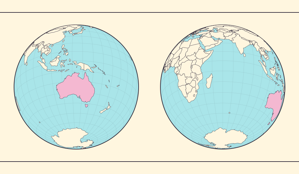
Rotate the globe slowly and follow one country. Near the center its outline opens up; near the edge it becomes a narrow sliver. Nothing has happened to the country. You are watching a curved surface from a changing direction.
The globe is also an image on a flat screen
RealWorldMap’s globe view uses an orthographic projection. PROJ describes this as a perspective azimuthal projection showing one hemisphere at a time. The visible disk is a way to depict a sphere, not a flat equal-area world map with a circular border.
A globe is useful, but its screen image is not an accurate area ruler. Near the edge you see the surface at a shallow angle; on the far side you do not see it at all. A country’s footprint in the image therefore depends on the viewpoint.
Šaltiniai: PROJ · Orthographic projection
Think of a sticker on a ball
Put an imaginary sticker on the front of a ball, then turn the ball. The sticker seems narrower as it approaches the side, although you have not cut or stretched it. The changing silhouette is foreshortening: a property of the view.
Country outlines behave in the same way. A coastal detail can disappear behind the visible horizon before the rest of the country does. Comparing a centered country with an edge-on country mixes geography with the angle from which you are seeing it.
Area is calculated before it becomes a silhouette
The Equal Earth atlas’s area estimate comes from spherical boundary geometry, not the number of visible pixels. Rotating the camera can change the silhouette without changing that geometric area, even when part of a selected country is hidden.
The globe is a good tool for orientation and for seeing the continuity of a curved world. For an area-ratio overview, Equal Earth supplies a more appropriate flat display. Do not infer a territory’s size from how much of its front-facing silhouette happens to remain visible.
Šaltiniai: D3 · Spherical area and distance
Move one country from center to rim
Search for a country to bring it toward the center, then rotate the globe slowly. Its outline narrows as it approaches the rim, and part of it disappears behind the visible hemisphere. Keep the zoom fixed: the change comes from the viewing angle, not a change in the country’s land.
Bring the country back toward the center and the hidden part returns. A Pacific Ocean divided between the ends of a flat world map also becomes a continuous surface on the globe. Rotation reveals both the country’s outline and the connections concealed by a flat map’s seam.
Šaltiniai: PROJ · Orthographic projection
Follow one outline from center to edge
- Open the globe and center Australia.
- Keep the zoom fixed and rotate until Australia approaches the edge.
- Return it to the center, then compare the same country on Equal Earth.
A shrinking silhouette is a change of view. It is not a change in the amount of ground.
Atverti žemėlapį →
Common questions
Why can I not see countries on the far side?
This view shows one hemisphere at a time. Rotate the globe to bring a country on the far side into view.
Can I compare areas by counting globe pixels?
Not reliably. The visible footprint changes with viewing angle and horizon clipping.
Sources and further reading
Sources checked:
Related stories
Ką išsaugo Equal Earth?
Paverčiant sferą plokštuma kai kurios savybės pasikeičia. Equal Earth išsaugo santykinius plotus, bet ne visas formas, atstumus ir kryptis. Gaublio krašte formos susispaudžia. Pasirinkite vaizdą pagal savo klausimą.
Why the shortest flight looks curved on a map
A straight line on the screen need not be the shortest path around Earth. Compare great-circle paths with compass bearings, and see what a route illustration can tell you.
Five questions before sharing a “true world map”
Projection, zoom, viewpoint, source detail and the meaning of area all affect how you read a map. Check these before sharing a comparison screenshot.