
This story is currently available in English and Korean. You are reading the English edition. 한국어 · English
Russia and Africa: width is not area
Russia is hard to miss on a rectangular world map: its outline runs across a large part of the northern edge. Africa appears below as a more compact shape. It is tempting to turn that width into an area judgement, but the comparison mixes shape, latitude and geographic categories.
Start with the scale of the two regions
UNData lists Russia’s surface area as about 17.10 million square kilometres. IPCC’s 1997 regional assessment, hosted by the UN library, describes Africa’s land area as about 30.24 million square kilometres. These figures show why visual width is a poor shortcut: Africa is larger despite Russia’s long northern outline.
The source definitions differ: surface area is not identical to land area. Use these rounded figures to establish the broad scale, not to publish a precise ratio to several decimal places. A careful comparison would first harmonise water coverage, territorial coverage and reference dates.
Források: UNData · Russian Federation: surface area · IPCC (1997) / UN Digital Library · Regional impacts: Africa
An outline can be long without filling much space
Think of a ribbon and a square with the same area. The ribbon can reach much farther across a page while using no more paper. A country’s maximum east-west extent similarly tells you about its reach, not directly about the land inside its outline.
The bounding rectangle is especially misleading for irregular regions. Sea, neighbouring countries and empty corners can occupy much of that rectangle. For an area question, compare the filled geometry or a documented area figure instead of the frame around it.
Northern enlargement adds a second effect
Mercator’s scale grows with latitude. Russia’s high-latitude position therefore adds enlargement to a shape that is already wide. Africa spans both sides of the equator, so the two outlines are not given the same local scale across a Mercator world map.
Switching to Equal Earth removes Mercator’s area-ratio distortion. Russia keeps its long shape and political boundaries. The amount of map space changes; the identity and extent of the regions stay the same.
Források: USGS · Map Projections: A Working Manual (Snyder, 1987) · PROJ · Equal Earth (Šavrič, Patterson & Jenny, 2018)
A long outline beside a broad continent
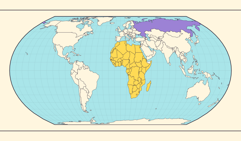
Find Russia, then inspect Africa without changing the zoom. Russia draws attention through its long east-west outline. Africa contains many country borders, so follow the continent’s outer coastline rather than treating each internal boundary as a separate edge of the comparison.
Equal Earth removes Mercator’s high-latitude area inflation. Russia remains long, but its length no longer suggests that it contains more land than Africa. Notice how a first impression based on horizontal reach differs from a comparison of the space inside each outline.
Források: PROJ · Equal Earth (Šavrič, Patterson & Jenny, 2018)
Separate reach from land footprint
- Locate Russia on Equal Earth and inspect its long east-west outline.
- Compare it with African regions at the same zoom.
- On the globe, rotate through Russia’s extent rather than judging a single edge-on view.
A wide outline and a large area are related observations, but they are not interchangeable measurements.
Térkép megnyitása →Common questions
Why not give an exact Africa-to-Russia ratio?
The cited sources use different area definitions. Rounded scale comparisons are safer until those definitions are harmonised.
Does Equal Earth make Russia a compact shape?
It reduces Mercator’s northern area inflation, while Russia’s long east-west outline remains. Length and area are different properties.
Sources and further reading
Sources checked:
Related stories
Africa is bigger than the map in your memory
The equator crosses Africa, but familiar rectangular maps give northern regions extra space. Compare Africa with countries you know to get a sense of its size.
Japan and Germany: a long shape can hide a similar area
An island chain and a compact mainland country look very different. Compare area without confusing the sea between islands with land.
Five questions before sharing a “true world map”
Projection, zoom, viewpoint, source detail and the meaning of area all affect how you read a map. Check these before sharing a comparison screenshot.