
This story is currently available in English and Korean. You are reading the English edition. 한국어 · English
Why the shortest flight looks curved on a map
A flight route arches northward on a world map. It looks like a detour until you imagine the same endpoints on a ball. The screen has flattened the surface, and “straight” now has two different meanings.
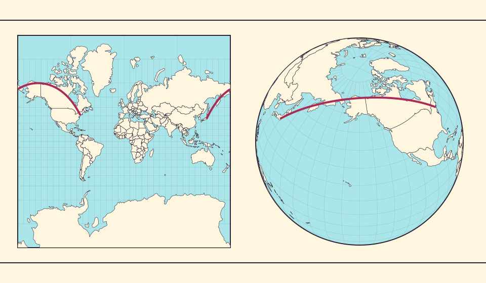
A shortest path along a spherical surface
A great circle is a circle on a sphere whose center is the sphere’s center. Except for exactly opposite endpoints, the shorter arc of the great circle through two points gives the shortest surface path on a perfect sphere. NASA’s navigation discussion explains why an aircraft’s heading changes along that path.
A flat line drawn across a world map is a different construction. The projection can bend a great-circle path when it turns geographic coordinates into screen coordinates. A curved-looking line is therefore not enough evidence that the journey is longer.
Izvori: NASA · Basics of Space Flight: reference systems · NASA · Great-circle navigation near the poles
Constant bearing answers another question
A rhumb line keeps a constant compass bearing. Mercator draws it as a straight line, which is one reason the projection is associated with navigation. A great-circle path generally changes bearing, so its line is generally curved on Mercator.
There are special cases, such as travel along the equator or a meridian. Avoid the shortcut “all flights curve north.” The appearance depends on the endpoints and projection. Distinguish the shortest spherical distance from a constant compass bearing.
Izvori: USGS · Map Projections: A Working Manual (Snyder, 1987)
A diagram is not an airline’s flight plan
The illustration is calculated from approximate city coordinates and a spherical model. It does not record an actual flight, predict the next departure or show that a particular airline follows this exact line. Those claims would need operational evidence.
Real routing has additional constraints, including airspace, weather and operational requirements. A great-circle illustration supplies a geometric reference, not a complete explanation of a flight’s duration. Use it to understand the map before using flight-specific data to explain an actual journey.
Tokyo and New York on one curved surface
Find Tokyo and New York in the illustration. A route near the ends of a flat world map can appear split by the map seam. Rotate a globe toward the Pacific and northern regions to see both cities as locations on one continuous curved surface.
The great-circle arc follows that surface. A route that bends upward on Mercator can still be the short arc on the sphere. Compare the illustration’s curve with a straight line on the page, then consider the spherical route rather than measuring the printed lines.
Izvori: NASA · Basics of Space Flight: reference systems · USGS · Map Projections: A Working Manual (Snyder, 1987)
Trace a journey around a ball
- Look at the calculated New York to Tokyo arc above.
- Open the globe and rotate until North America and East Asia are near the visible Pacific.
- Compare that continuity with the two edges of a flat world map.
Read a route in geographic space before judging it by the shape of a line on a page.
Otvori kartu →Common questions
Does every real flight follow the great circle exactly?
No. A great circle is a geometric reference; actual flight planning has additional constraints.
Can a curved line on the map represent the shorter route?
Yes. A projection changes how a spherical route is drawn. The short great-circle arc can appear curved on Mercator.
Sources and further reading
Sources checked:
Related stories
The map edge is not the International Date Line
Longitude wraps around, a flat map has a seam, and calendar dates have a boundary. These three ideas are related but not identical.
Why a country looks smaller at the globe’s edge
A globe avoids the familiar rectangular world, but its screen image still compresses the edge. Separate spherical area from visible footprint.
Why online maps stop before the poles
Square tiles make a world map easy to zoom, but Mercator cannot place the poles at a finite height. Learn what the missing polar strip means.