
This story is currently available in English and Korean. You are reading the English edition. 한국어 · English
Five questions before sharing a “true world map”
A before-and-after map can change your view of the world in seconds. It can also hide the settings that produced the difference. Before sharing a striking “true size” image, ask these five questions to understand what caused the difference.
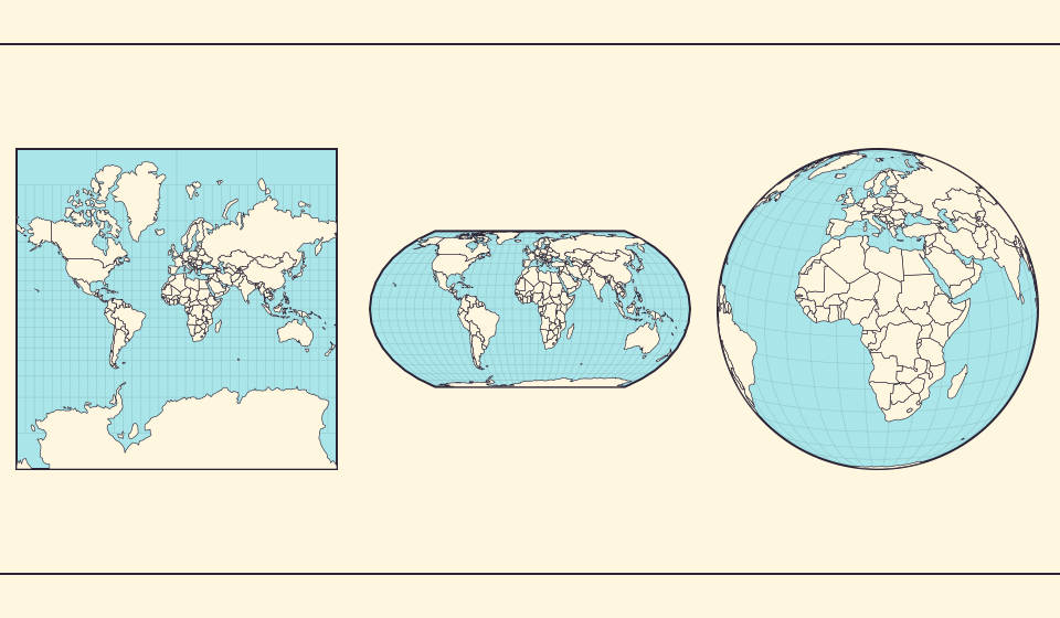
1. Which geometric property is preserved?
Read the projection name first. Equal Earth preserves relative area; Mercator preserves local angles; an orthographic globe shows one hemisphere. To judge a map’s “accuracy,” first decide which quantity you want it to represent accurately.
If the question is about country area, a screen full of land is not enough. If the question is about distance, an equal-area label does not solve it. Write the intended question in one sentence before choosing the view.
Fuentes: Library of Congress · Geospatial reference data: projection properties
2. Are the display scales comparable?
Two country thumbnails can each be fitted to their own frame. That makes them readable, but it can make a small country look as large as a big one. A similar problem occurs when a screenshot is taken before and after changing the zoom.
For a visual area comparison, use a common scale and say so in the caption. If panels have independent scales, use them to compare detail or distortion patterns instead of absolute footprint. The caption should make this clear so readers do not mistake the illustration for an area comparison.
3. Are you comparing the center with the edge?
On the globe, a country near the edge is foreshortened and may be partly hidden. A small visible footprint does not establish a small territory. Center the relevant region and keep the zoom consistent before comparing outlines.
On a flat world map, the central meridian and seam also matter. A region split across the edges can seem widely separated even when it is continuous on the sphere. Name the view’s center if it is important to the comparison.
Fuentes: PROJ · Orthographic projection
4. How detailed is the boundary source?
A world overview needs less detail than a harbour map. Natural Earth’s different source scales serve different uses, and enlarging the overview cannot restore every omitted island. Ask what source the author used, not only how many pixels the image contains.
Simplified boundaries are useful for learning and visualisation. The problem starts when an overview outline is presented as a precise official measurement without a method or qualification. Match the claim’s precision to the source’s purpose.
Fuentes: Natural Earth · Dataset scales
5. What does the area number include?
Check whether the figure describes land area, surface area or an estimate from a displayed polygon. Water coverage and territorial coverage can change the answer. A unit such as km² is necessary, but it is not a complete definition.
Include the regions, projection, common scale, source and area definition when sharing a comparison. A short caption can give readers enough information to understand what the image shows and what it does not measure.
Fuentes: World Bank · Land area: definition · World Bank · Surface area: definition
Explain one comparison in a caption
- Choose two countries and compare them at a fixed zoom.
- Check the same pair on Equal Earth and the globe.
- Write a caption naming the view, the source and whether the area is a geometric estimate or a statistic.
Explain the comparison conditions in a “true size” image so readers can reproduce the result.
Abrir mapa →Common questions
Is there one perfect map for every question?
No flat projection preserves every geometric property. Choose a view for the specific question.
Must every comparison use official statistics?
Not for a clearly labelled visual experiment. Numerical claims need a defined, appropriate measurement source.
Sources and further reading
Sources checked:
Related stories
Lo que conserva Equal Earth
Aplanar una esfera cambia algunas propiedades. Equal Earth conserva las áreas relativas, pero no todas las formas, distancias y direcciones. En el borde del globo las formas se comprimen. Elige la vista según la pregunta que quieras responder.
Por qué cambian fronteras y áreas
La simplificación omite pequeñas bahías e islas. Usamos límites de Natural Earth a escala 1:110 millones y calculamos áreas a partir de geometrías esféricas simplificadas. Las cifras oficiales pueden incluir agua y territorios de otra manera. ≈ señala una estimación.
The map edge is not the International Date Line
Longitude wraps around, a flat map has a seam, and calendar dates have a boundary. These three ideas are related but not identical.