
This story is currently available in English and Korean. You are reading the English edition. 한국어 · English
The map edge is not the International Date Line
Two islands can appear near opposite ends of a world map even when the globe places them near each other. The page needs a place to cut a continuous surface. The calendar needs a way to separate dates. Those choices meet in the Pacific, but they are not the same line.
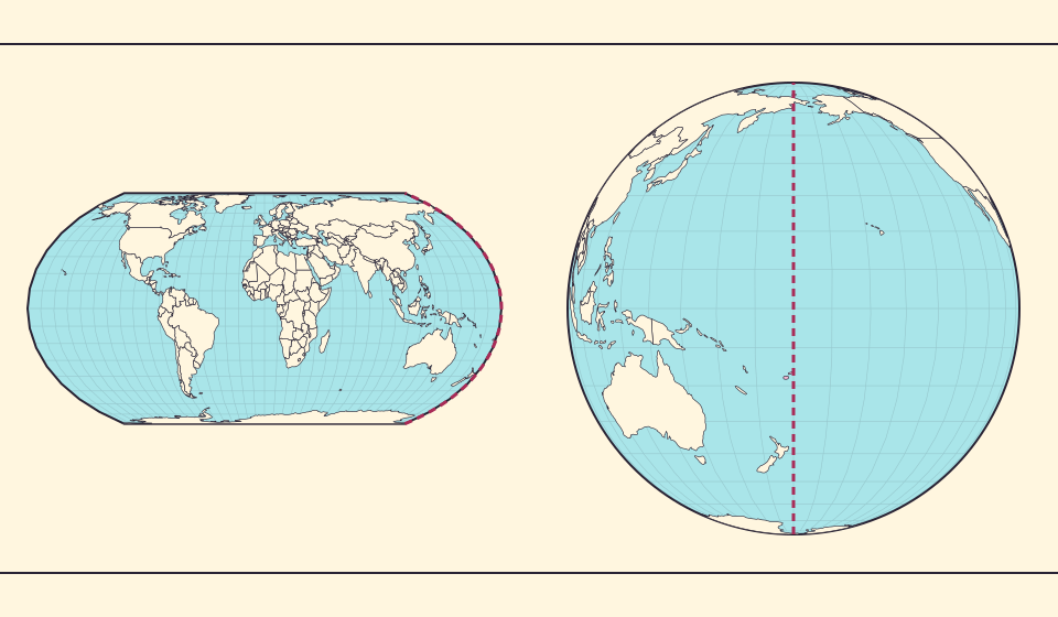
180° east and 180° west meet
Longitude describes a position around Earth. The +180° and −180° descriptions meet at the same meridian. A coordinate can therefore cross from a large positive value to a large negative value while the physical path remains continuous.
On a flat map centered on Greenwich, that meridian often becomes the left and right seam. A country or island group crossing it may be split between the edges. The two pieces are not necessarily distant neighbours; they are separated by the drawing’s cut.
The date boundary bends around places
NOAA describes the International Date Line as a boundary between consecutive calendar dates, running roughly through the mid-Pacific near 180° longitude. It bends around political borders and island groups. It is not simply the straight meridian printed on every world map.
NOAA also notes that countries choose the dates they observe; the line has no single international legal status. For a particular island’s current local date or time zone, use current local rules rather than treating a geometric longitude as a calendar answer.
Changing the center changes the apparent gap
Center a globe on the Pacific and the ocean that occupied the page edges becomes the middle of the view. East Asia, Oceania and the Americas acquire a different visual relationship. No island has moved; the display has moved its focus.
Page edges can make places look farther apart. A screenshot alone can conceal whether a long line crosses a seam or genuinely spans a large part of the globe. Check the central meridian and the continuity of the surface before interpreting the gap.
Bronnen: PROJ · Orthographic projection
A calendar boundary and a map seam
The 180-degree meridian describes a location; the International Date Line separates calendar dates. The dotted line in this illustration is the meridian. The actual Date Line bends around islands and political borders, so it does not match that straight guide everywhere.
Cross the actual Date Line westward and the calendar advances a day; cross eastward and it goes back a day. Crossing a flat map’s seam only changes where a location is drawn. Keeping those two boundaries separate explains why a Pacific journey can appear to gain or lose a calendar day.
Find the Pacific’s continuity
- Find Fiji on Equal Earth and note its position near the map seam.
- Switch to the globe and rotate to a Pacific-centered view.
- Compare geographic continuity with the dashed 180° meridian in the illustration.
A coordinate seam, a page edge and a date boundary should each be named before they are compared.
Open kaart →Common questions
Is the International Date Line exactly 180° everywhere?
No. It roughly follows that meridian but bends around borders and island groups.
Does crossing a map edge mean crossing the date line?
Not necessarily. The map can be centered and cut at different meridians, while calendar boundaries follow their own rules.
Sources and further reading
Sources checked:
Related stories
Why the shortest flight looks curved on a map
A straight line on the screen need not be the shortest path around Earth. Compare great-circle paths with compass bearings, and see what a route illustration can tell you.
Why a country looks smaller at the globe’s edge
A globe avoids the familiar rectangular world, but its screen image still compresses the edge. Separate spherical area from visible footprint.
Five questions before sharing a “true world map”
Projection, zoom, viewpoint, source detail and the meaning of area all affect how you read a map. Check these before sharing a comparison screenshot.